There is an excellent initiative from The Global Biodiversity Information Facility (GBIF), Finnish Biodiversity and the Biodiversity Data Journal to waive publication fees for papers outlining biodiversity records from Russia.
The MOOD spatial data website is now up and running and MOOD partners are supporting the efforts researching the nCoV-2019 Corona virus outbreak in Wuhan province and beyond.
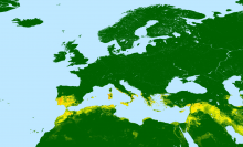
Please be notified that multiple Midge models are now available to PALE-Blu partners to download. The summary document outlining all the models including jpgs are available to registered members of the site. Models are available on request.
The summary document can be downloaded by registered users at http://www.palebludata.com/?q=data from the following directory: PALE-Blu Data / PB Species Distribution
Our 2018 annual co-ordination meeting will be held in Rabat, Morocco on the 19th and 20th of September 2018. Our partner/hosts in Rabat will be Pr. Ouafaa fassi Fihri and Pr. Thomas Balenghien.
More details to follow...
We look forward to seeing our project partners there!
Our project website can be found at www.paleblu.eu. The website provides more detailed information on the project and its aims and objectives. Its project partners, how the project is structured and further information on the bluetongue virus and the control and prevention strategies currently used.
To keep up to date with the project please check back often and follow the project twitter feed https://twitter.com/PALEBluH2020
The ESA CCI Land cover data supercedes previous ESA GLOBCover datasets. This similar product remains at 300m scale with similar land classes as GLOBCover and can be compared for land cover change.
From the ESA CCI land cover documentation: The CCI-LC project delivers consistent global LC maps at 300 m spatial resolution on an annual basis from 1992 to 2015. The Coordinate Reference System used for the global land cover database is a geographic coordinate system (GCS) based on the World Geodetic System 84 (WGS84) reference ellipsoid.
The World Database on Protected Areas (WDPA) is the only global database of protected areas. It is a joint effort between IUCN and UNEP, managed by UNEP-WCMC, to compile protected area information for all countries in the world from governments and other authoritative organizations which are referred to as data providers. The WDPA underpins Protected Planet at www.protectedplanet.net, where it can be viewed and downloaded and the database is integrated with other relevant information.
The PALE-Blu Kick-off meeting presentations are now available to download to PALE-Blu partners.
They can be downloaded from http://www.palebludata.com/?q=data in the following directory PALE-Blu Data > PALE-Blu Meetings > PALE-Blu Kick-off meeting 09/2017.
This population layer provides baseline GPWv4 population values which are replaced with worldPop data where available. All values are adjusted to UN population figures where possible. Please consult the excel file included in this download for more detailed information on the data by country.
This is the recommended 1km baseline population layer for the PLE-Blu project. It is available to everyone who registes on the PALEBlu website. See the home page for information on how to do this.
 There is an excellent initiative from The Global Biodiversity Information Facility (GBIF), Finnish Biodiversity and the Biodiversity Data Journal to waive publication fees for papers outlining biodiversity records from Russia.