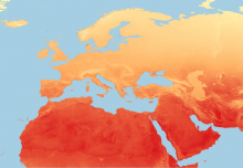
The latest release of 1km resolution images produced by Temporal Fourier analysis of global VIIRS data. The imagery summarises some key environmental indicators, incorporating seasonal dynamics, for the PALE-Blu study area. This version of the Fourier processed imagery has been applied to a time series of version 1 VIIRS data for 2012-20.
The latest release includes the Middle Infra-red (MIR) band 03, Day and Night Land Surface Temperature (DLST & NLST) bands 07 and 08, the Normalized Difference Vegetation Index (NDVI) band 14 and the Enhance Vegetation Index (EVI) band 15.
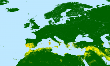
This is a set of images for a European and North Africa extent of 1km averages of the Copernicus Global Land Service: collection 3: epoch 2019 - Percentage Land Cover 100m datasets as described at https://doi.org/10.5281/zenodo.3939049
Produced by the global component of the Copernicus Land Service, derived from PROBA-V satellite observations and ancillary datasets.
The maps include a set of versatile cover fractions: percentage (%) of ground cover for the 10 main classes:
This is a set of 1km images produced by Temporal Fourier analysis of ECWMF ERA5-Land total Precipitation. The imagery summarises some key environmental indicators, incorporating seasonal dynamics, for the PALE-Blu study area.
The latest release of 1km resolution images produced by Temporal Fourier analysis of global MODIS data. The imagery summarises some key environmental indicators, incorporating seasonal dynamics, for the PALE-Blu study area. This version of the Fourier processed imagery has been applied to a time series of version 6 MODIS data for 2001-19.
The latest release includes the Middle Infra-red (MIR) band 03, Day and Night Land Surface Temperature (DLST & NLST) bands 07 and 08, the Normalized Difference Vegetation Index (NDVI) band 14 and the Enhance Vegetation Index (EVI) band 15.
Please be notified that multiple Midge models are now available to PALE-Blu partners to download. The summary document outlining all the models including jpgs are available to registered members of the site. Models are available on request.
The summary document can be downloaded by registered users at http://www.palebludata.com/?q=data from the following directory: PALE-Blu Data / PB Species Distribution
This dataset is available to PALE-Blu project partners on request. Please email info@palebludata.com if you require access to this data.
European Wind characteristics at 10m in height derived from the European Centre for Medium-Range Weather Forecasts (ECMWF) reanalyses (ERA) data. The data defines characteristics such as windspeed direction from and direction. Monthly mean values for the years 2005-2017 at 0.125 of a degree Clipped to the PALE-Blu extent.
The latest release of 1km resolution images produced by Temporal Fourier analysis of global MODIS data. The imagery summarises some key environmental indicators, incorporating seasonal dynamics, for the PALE-Blu study area. This version of the Fourier processed imagery has been applied to a time series of version 6 MODIS data for 2001-16.
The latest release includes the Middle Infra-red (MIR) band 03, the Normalized Difference Vegetation Index (NDVI) band 14 and the Enhance Vegetation Index (EVI) band 15.
The ESA CCI Land cover data supercedes previous ESA GLOBCover datasets. This similar product remains at 300m scale with similar land classes as GLOBCover and can be compared for land cover change.
From the ESA CCI land cover documentation: The CCI-LC project delivers consistent global LC maps at 300 m spatial resolution on an annual basis from 1992 to 2015. The Coordinate Reference System used for the global land cover database is a geographic coordinate system (GCS) based on the World Geodetic System 84 (WGS84) reference ellipsoid.
The World Database on Protected Areas (WDPA) is the only global database of protected areas. It is a joint effort between IUCN and UNEP, managed by UNEP-WCMC, to compile protected area information for all countries in the world from governments and other authoritative organizations which are referred to as data providers. The WDPA underpins Protected Planet at www.protectedplanet.net, where it can be viewed and downloaded and the database is integrated with other relevant information.